
فائل:Mississippi Delta Lobes.jpg
Mississippi_Delta_Lobes.jpg (800 × 484 پکسل، فائل کا حجم: 73 کلوبائٹ، MIME قسم: image/jpeg)
From : http://en.wikipedia.org/wiki/Image:Mississippi_Delta_Lobes.jpg
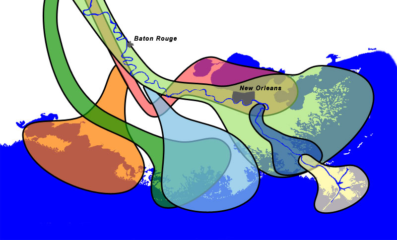
| Salé-Cypremort | 4600 years BP | |
| Cocodrie | 4600–3500 years BP | |
| Teche | 3500–2800 years BP | |
| St. Bernard | 2800–1000 years BP | |
| Lafourche | 1000–300 years BP | |
| Plaquemine | 750–500 years BP | |
| Balize | 550 years |
خلاصہ
The lobes of the Mississippi River Delta that formed over thousands of years due to deltaic switching.


Sources
- Wicander,Monroe (1993) Historical Geology - Evolution of Earth and Life through Time، West Publishing Company ISBN 0314012400 [1]
- Kolb,van Lopik (1958) Geology of the Mississippi River deltaic plain, southeastern Louisiana. Technical Report 3-483، Vicksburg, MS: U.S. Army Corps of Engineers Waterways Experiment Station (PDF, 6.86MB) [2]
- Delta Complexes of Mississippi River Deltaic Plain, Frazier, 1967 [3]
اجازہ کاری
| میں اس تخلیقی کام کے حقوق کا مالک ہوں اور اسے دائرہ عام میں شائع کرتا ہوں جس کا اطلاق عالمی سطح پر ہوتا ہے۔ بعض ملکوں میں یہ قانونی طور پر شاید ممکن نہ ہو؛ اگر ایسا ہے تو: میں ہر ایک کو کسی بھی مقصد کے لیے بغیر کسی شرط کے اس تصویر کے استعمال کا حق تفویض کرتا/کرتی ہوں، بجز اس صورت کے جس میں کوئی قانونی رکاوٹ موجود ہو۔ |
Coast and river images from the National Map Server. Lobe outlines originally traced directly from Wicander and Monroe, 1993, but the shorline and river didn't match the USGS data, so the outlines had to be reinterpretted slightly.
Final Photoshop layers can be found here, in case updates are needed.
فائل کا تاریخچہ
کسی خاص وقت یا تاریخ میں یہ فائل کیسی نظر آتی تھی، اسے دیکھنے کے لیے اس وقت/تاریخ پر کلک کریں۔
| تاریخ/وقت | تھمب نیل | ابعاد | صارف | تبصرہ | |
|---|---|---|---|---|---|
| رائج الوقت | 12:51، 30 دسمبر 2006ء | | 800 × 484 (73 کلوبائٹ) | Urban~commonswiki | From : http://en.wikipedia.org/wiki/Image:Mississippi_Delta_Lobes.jpg {| |<div class="key" style="background-color:#FFA447; width:1.5em; height:1.5em; border: 2px solid black"> </div> |Salé-Cypremort |4600 years [ |
روابط
درج ذیل صفحہ اس فائل کو استعمال کر رہا ہے:
فائل کا عالمی استعمال
مندرجہ ذیل ویکیوں میں یہ فائل زیر استعمال ہے:
- ar.wikipedia.org پر استعمال
- de.wikipedia.org پر استعمال
- en.wikipedia.org پر استعمال
- en.wikiversity.org پر استعمال
- et.wikipedia.org پر استعمال
- fr.wikipedia.org پر استعمال
- he.wikipedia.org پر استعمال
- hu.wikipedia.org پر استعمال
- pt.wikipedia.org پر استعمال
- sl.wikipedia.org پر استعمال
- tr.wikipedia.org پر استعمال
- zh.wikipedia.org پر استعمال