
فائل:Greece in 1210.svg

اس SVG فائل کی PNG نمائش کا حجم: 800 × 456 پکسلز دیگر تصمیمات: 320 × 182 پکسلز | 640 × 365 پکسلز | 1,024 × 584 پکسلز | 1,280 × 730 پکسلز | 2,560 × 1,460 پکسلز | 3,508 × 2,000 پکسلز۔
اصل فائل (ایس وی جی فائل، ابعاد 3,508 × 2,000 پکسل، فائل کا حجم: 1.12 MB)
خلاصہ
| تفصیل |
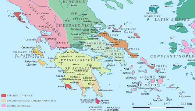
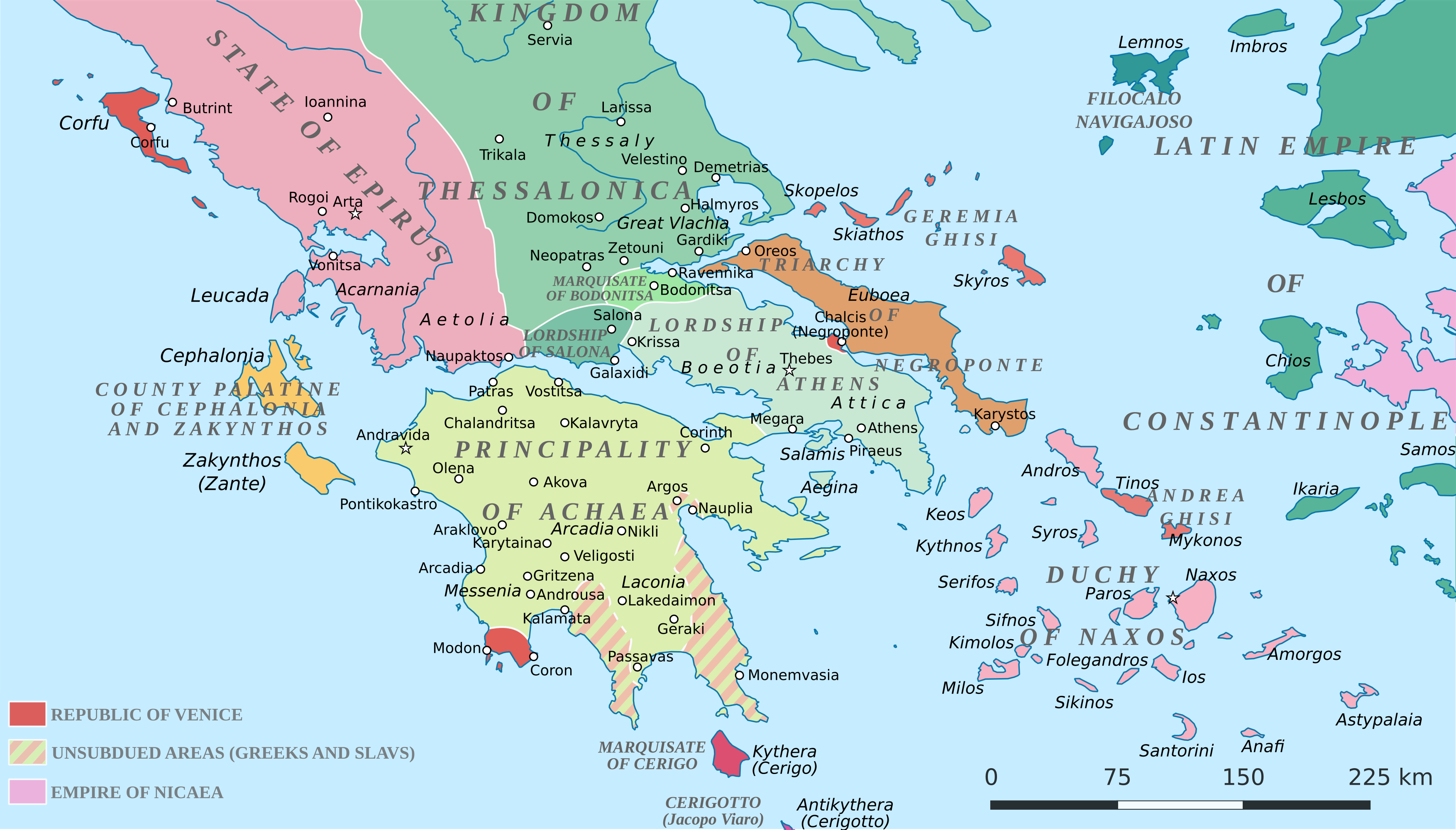
English: Political map of southern Greece in c. 1210, after the establishment of the Crusader states following the Fourth Crusade. |
| تاریخ | |
| ماخذ |
SVG base from File:Greece in 1210V1.svg; based on the original political map by William Miller (1908), with changes and corrections to account for newer scholarship:
|
| مصنف | Cplakidas |
| دوسرے نسخے |
|


اجازہ کاری
میں اس تخلیقی کام کے حقوق کا مالک ہوں اور اسے مندرجہ ذیل اجازت نامے کے تحت شائع کرتا ہوں:
This file is licensed under the Creative Commons Attribution-Share Alike 4.0 International license.
- آپ آزاد ہیں:
- شیئر کرنے – کام کو نقل، تقسیم یا منتقل کرنے کے لیے
- ریمکس کے لیے – کام منبطق کرنے کے لیے
- مندرجہ ذیل شرائط کے تحت:
- انتساب – آپ کو اس کام کا انتساب مصنف یا اجازت دہندہ کے بتائے گئے طریقہ کے مطابق دینا ہوگا (تاہم یہ انتساب اس طرح نہیں ہونا چاہیے کہ اسے دیکھ کر ایسا محسوس ہو کہ اصل مصنف یا اجازت دہندہ آپ کے یا آپ کے ذریعہ اس کام کے استعمال کرنے کے حامی ہیں)۔
- یکساں شراکت – اگر آپ اس کام میں کوئی تبدیلی یا ترمیم کرتے ہیں یا اس کام پر مبنی کچھ نیا بناتے ہیں تو اسے بھی آپ اسی یا اس جیسے کسی اجازت نامے کے تحت شائع کر سکتے ہیں۔
فائل کا تاریخچہ
کسی خاص وقت یا تاریخ میں یہ فائل کیسی نظر آتی تھی، اسے دیکھنے کے لیے اس وقت/تاریخ پر کلک کریں۔
| تاریخ/وقت | تھمب نیل | ابعاد | صارف | تبصرہ | |
|---|---|---|---|---|---|
| رائج الوقت | 19:59، 23 جون 2017ء | | 3,508 × 2,000 (1.12 MB) | Cplakidas | fixed three names to paths |
| 12:08، 11 اپریل 2017ء |  | 3,508 × 2,000 (1.1 MB) | Cplakidas | colour changes | |
| 11:48، 11 اپریل 2017ء |  | 3,508 × 2,000 (1.11 MB) | Cplakidas | tweak around Coron | |
| 10:39، 11 فروری 2017ء |  | 3,508 × 2,000 (1.11 MB) | Cplakidas | tweaks in Negroponte, unsubdued areas | |
| 17:57، 8 فروری 2017ء |  | 3,508 × 2,000 (1.11 MB) | Cplakidas | tweaking the Morea | |
| 13:40، 8 فروری 2017ء |  | 3,508 × 2,000 (1.11 MB) | Cplakidas | slight tweaks | |
| 13:14، 8 فروری 2017ء |  | 3,508 × 2,000 (1.11 MB) | Cplakidas | User created page with UploadWizard |
روابط
درج ذیل صفحہ اس فائل کو استعمال کر رہا ہے:
فائل کا عالمی استعمال
مندرجہ ذیل ویکیوں میں یہ فائل زیر استعمال ہے:
- ar.wikipedia.org پر استعمال
- az.wikipedia.org پر استعمال
- bg.wikipedia.org پر استعمال
- ca.wikipedia.org پر استعمال
- da.wikipedia.org پر استعمال
- de.wikipedia.org پر استعمال
- el.wikipedia.org پر استعمال
- en.wikipedia.org پر استعمال
- eo.wikipedia.org پر استعمال
- eu.wikipedia.org پر استعمال
- fa.wikipedia.org پر استعمال
- fr.wikipedia.org پر استعمال
- gl.wikipedia.org پر استعمال
- hr.wikipedia.org پر استعمال
- id.wikipedia.org پر استعمال
- it.wikipedia.org پر استعمال
- ja.wikipedia.org پر استعمال
- ko.wikipedia.org پر استعمال
- ro.wikipedia.org پر استعمال
- ru.wikipedia.org پر استعمال
اس فائل کا مزید عالمی استعمال دیکھیے۔